• Stacks Image 14443

    Caption Text

    Link

Groundwater

WRA has experience of groundwater development, management and conservation in most global geologies. The company has provided advice on centralised management of groundwater for large-scale irrigation and water supply projects, as well as development, design and implementation of regional, city and rural water supply schemes, designing and supervising the installation or rehabilitation of individual boreholes, wellfield supplies, aquifer drains, radial collector wells, adits, dug-wells and aflaj [qanat].

Smaller-scale projects have included irrigation and potable water supplies for farms and private properties. Unusual projects have included the exploitation of shallow sand aquifers on islands and cutting water supply drains through fibrous tropical peat.

WRA’s groundwater activities include assessment of groundwater deployable output for the British water industry at many levels, groundwater modelling, groundwater quality assessment with particular reference to nitrates and hydrocarbons, water quality modelling, and the writing and use of specialised software for tackling complex problems, particularly related to borehole design, pumping test analysis and deployable output assessment.

WRA, through its associates, has the in-house capability to provide groundwater monitoring, drilling, soil and aquifer test services at many global locations.

WRA Clients and Countries

WRA’s clients include the Environment Agency, water companies, research agencies, foreign governments, industrial and private developers and the tourism industry. 

WRA has groundwater experience in the following countries: Angola, Azerbaijan, France, Indonesia, Lebanon, Malaysia, Moldova, Morocco, Mozambique, Portugal, Somaliland, Timor Leste, Thailand, UAE and UK.

Groundwater Studies

  • International Studies
    Bintan Industrial Estate Water Supply, 1994-1995, 2001-2002
    [BIEM, Sembcorp Parks Management, Riau Archipelago, Indonesia]

    Following the review of water resources of the Lobam-Busung Peninsula in 1994, a wide range of options were investigated to establish the new industrial site, which included construction of exploratory and production boreholes to abstract 2 Mld from shallow groundwater, with further expansion from the Lake Java sandpits, and in the long-term dam construction.

    To meet increased demand on the industrial estate, water supply was increased to 6.5 Mld, from 1995 to 1997, by doubling the groundwater production, and increasing the storage characteristics of Lake Java by embankment raising and spillway construction. Due to multiple-source blending difficulties, groundwater from the well-field in 1999 was pumped directly into Lake Java, so that pre-mixed ground and surface water could be delivered, by the Lake Java pumping station, to the treatment plant on the industrial estate.

    The WRA project looked at options to increase water supply to 7 Mld in the short-term, and then to 12 and 18 Mld in the medium-term. The project reviewed and costed all the identified schemes, including the combination of water supply with excavation for landfill materials. A strategy was developed for managing drawdown in lake water level during drought conditions. Water chemistry was reviewed and process tests performed on site, to optimize water treatment parameters, and investigate requirements for treatment of highly discoloured peat swamp water.


    Wazzani Springs Groundwater Assessment, 2002-2003
    [EU/Relex, Lebanon]

    The Wazzani Spring study aimed to determine the impact of water supply abstraction from springs in the Hasbani River on River Jordan inflows, as part of a process for the Lebanese-Israeli governments to agree an approach to equal-sharing of the resources of the Upper Jordan catchment. One component of the project focused on the groundwater resources of the Mount Hermon limestone aquifer, and quantified water availability and the amount naturally discharging to the river system.

    The groundwater component was accompanied by hydrological modelling of surface flows as far as the Sea of Galilee and irrigation/land-use studies as the basis for irrigation demand.


    Quinta de Carvalhal Hydrogeological Study, Portugal, 2007
    [M José Bacilar e Fernando Magalhães]

    Carvalhal in the Braga District of Northern Portugal is located in the Central and West Minho Geological Formation, where borehole productivity is typically 1 to 2.5 l/s. Groundwater at the farm is fed primarily from a recharge catchment of 0.9 km2 on the granite outcrop of Monte Busto and would likely support an annual consumption by 225Ml.

    Hydrogeological study was made to site production boreholes for water supply and irrigation borehole construction along fracturing associated with a SE-NW fault, which is aligned along the valley of the Ribeira de Poriço and then extends to the low-lying area south of Carvalhal.

    A well inventory showed that all houses in the neighbourhood have wells between 5 and 10 m deep, capturing water circulating in the weathered mantle of mica-schist. South of Carvalhal terrain elevation is lower, sloping down to the headwaters of a Poriço tributary, and it was found that well productivity was higher along the line of this valley.

    The investigation designed a new borehole to capture water at depths between 70 and 100 m, to intercept groundwater associated with NW-SE fault, and connected to the main alignment of the Ribeira do Poriço, with an expectation of producing between 1 and 2.5 l/s, on the southern margin of the property.


    Sangachal and Serenja Hydrogeological appraisal and monitoring, 2009
    [BP Caspian Sea Ltd, Azerbaijan]

    Implementation of a Groundwater survey & annual contaminant monitoring reports. Groundwater monitoring had been carried out in the vicinity of the Serenja Hazardous Waste Management Facility [HWMF] intermittently since 1998. In 2008, the groundwater monitoring network was expanded with the installation of new boreholes. WRA reviewed all the information obtained to-date to provide hydrogeological interpretation & recommendations for future monitoring.

    Potential sources of contaminants, pathways for contaminant migration and receptors to contaminants were assessed. A range of potential sources were identified, from current activities including transport of oily water, from historical sources such as the bioremediation area and construction of the AA Services and HWMF compounds and from airborne contaminants. The concrete base in the HWMF treatment facility provides protection to the ground from waste at the facility. The clay rich sediments provide some protection to the groundwater from any contamination at the ground surface. Although small-scale contamination of groundwater was found, the level of contamination did not present an immediate risk to water resources or other receptors, in the vicinity of the site.

    The highest concentrations of petroleum hydrocarbons and light aromatic hydrocarbons were found in the north-west of the Serenja site, particularly benzene and toluene.

    Recommendations were given to continue monitoring after some adjustment to the analytical suite, and to carry out a set of permeability tests to accurately determine hydraulic conductivity.


    Gaban Groundwater Basin study, Somaliland, 2012
    [Abu Dhabi Development Fund]

    A yield assessment of the Gaban groundwater basin formed part of the hydrological Studies for a new dam on Tug Biyoguure, to reinforce Berbera’s water supply.

    The original Berbera water supply came from the Dubar Spring, which fell into disrepair during the civil war. The 2012 population of 30,000 with 0.3 million livestock required a supply of 2.25 Mld. The human population was expected to grow to 165,000, and livestock up to 1.3 million, resulting in a combined water demand of 17.65 Mld in 2022.

    Catchments were defined using DEM on ArcGIS, and analysed to provide hydrological parameters, and define the surface catchment area of 645 km2 and maximum elevation of 1657 m MSL. The construction of a 10-metre high dam aimed to capture the togga baseflow at the site. Including a 2.5 Mld compensation flow for existing irrigation of crops downstream, estimated to be 14% to 32% of predicted baseflow.

    The Daban Groundwater Basin is a down-faulted block between the coastal range and Sheikh Mountain. The Dagha Shabel Fault forms the southern limit of the Daban Basin, creating a sub-Basin south of the fault with an inlier of Jurassic sediments at the western end, also producing permanent water. Mean annual rainfall across the Daban Basin varies from 75 to 200 mm covering an estimated area of 790 km2. Tug Biyoguure has eroded along a NW-SE fault through the Calween Range producing a natural “line-sink” for groundwater trapped behind the impermeable Taleh Series, and fed by rainfall and runoff from Sheikh Mountain to the south.

    Tug Biyoguure baseflow was estimated at 17.8 Mld, equivalent to 6.5 Mm3/yr, or 8.2 mm/yr. The potential increase in flow across the Auradu and Yesomma Gorge is unclear, but a contribution of 56% of dam baseflow was estimated based on regional aquifer hydraulics.


    Villa Maryland hydrogeological investigation, Nice, France, 2014
    [SCI Villa Maryland]

    Villa Maryland is an exclusive property at St Jean Cap Ferrat on the Mediterranean coast which has 1.6 hectare ornamental gardens irrigated using mains water supply, and the lower slopes of the property suffered from permanent waterlogging of the soil. Water was reported to discharge from the drainage system continuously all year around. Geological appraisal and assessment of groundwater, drainage and irrigation requirements was able to confirm hydrogeology and pin-point the location of a large leak from the piped water supply system. The work involved the logging and interpretation of a suite of small diameter boreholes, local water well inventory to determine the depth of groundwater in the aquifer, and interpretation of local geology and water chemistry.

    The drainage and stormwater system was surveyed and tracers used to determine the flow routes of water on site.

    The property has a clay soil of very low permeability overlying impermeable marl, except on the higher ground where soil overlies Quaternary conglomerate. This explains swelling on saturation and surface waterlogging after rainfall or irrigation. Garden walls exacerbate the soil waterlogging, as they act as impermeable barriers for overland flow and help retain soil moisture. The existing drains receive little infiltration and leave the soil saturated.

    The study has shown that the permanent flow of water in the main drain at the bottom of the property is caused by leakage in the water distribution system, confirmed by water chemistry, geology, soils and permanence of flow.


    Groundwater recharge and Falaj reinstatement, UAE, 2015
    [UAE Ministry of Environment and Water]

    A project to review seepage and groundwater recharge at selected dam sites in the Hajjar Mountains, was combined with a feasibility study for reinstatement of falaj at Fili and Al Mualla.

    Seepage was investigated at the following dams: Al Hayl, Wurraya, Qecheech, Sifuni, Mamdouh, Buraq, Moudainah and Muzeira. A review was made of the Fili dams and the groundwater recharge mechanism in the southern part of the Meleiha Plain which is affected by the Buraq and Fili recharge dams.

    The design philosophy to build UAE dams using semi-permeable embankment materials means that seepage water will be generated, safely controlled by drainage filters at the base of the dam. Seepage discharge then infiltrates wadi gravel aquifers downstream of the dam, minimising the residence time and evaporative losses of water in the reservoir.

    When large amounts of sediment accumulate in the reservoir basins, this prohibits infiltration, and the reservoirs act unfortunately as giant siltation and evaporation ponds.

    Better practice was identified whereby draw-off towers are opened in stages after a flood has passed, to allow the stored water to flow downstream and infiltrate into wadi gravels. Only one dam in UAE [Showkah Dam] was operated this way, because it is a concrete gravity dam.

    The geology and catchment configuration of the Fili Falaj indicated that this underground gallery [qanat] could be successfully reinstated to former productivity, provided that work is undertaken to improve the process of recharge at the Fili Dams.

    Local farms use groundwater from deep aquifers, which are naturally more mineralised and are becoming increasingly brackish due to over-exploitation. In contrast, the falaj intercept shallow groundwater so deep abstraction will not necessarily interfere with the falaj reinstatement.

    Falaj Al Mualla was being supported by pumping from deep abstraction boreholes, so likewise not sustainable unless the recharge imbalance was addressed.


    Hamboweene Dam hydrological study, Somaliland, 2015
    [Abu Dhabi Development Fund]

    A small dam downstream of the village of Hamboweene was designed and built, to the north-east of Hargeisa in Somaliland, with the objective of improving water available for livestock in the area.

    Runoff from the farmed plateau west of Hargeisa contributes to togga Maroodi Jeex and joins flow from the southeast in toggas Lugud and Lehia, and togga Daraweina in the west, to form togga Hamboweene at the dam site and on through the Dhubatto Gorge. From the village of Hamboweene, the togga valley cuts down into basalts of the Aden Volcanic Series which are exposed at the proposed dam site, and psammite is exposed underneath the basalt in small cliffs eroded by togga Hamboweene downstream of the proposed dam site, and through the Dhubatto gorge.

    Part of the design and construction studies included an assessment of shallow aquifer recharge from toga flows which maintains baseflow exploited by pits and dug wells in the alluvial sand filling the Maroodijeex valley.

    Groundwater circulation in the Nubian is deep just above the basement floor, and well beyond the surface sphere of influence affecting baseflow in the togga Hamboweene. There is small-scale fissure-flow in the basement complex, which acts more as a barrier at outcrop to south-north water circulation in the Hamboweene catchment.

    There are waterholes downstream of the dam-site at the junction of the psammite and overlying basalt which implies that there is groundwater circulation along this contact zone.
  • UK Studies
    Wallers Haven Study, East Sussex, UK, 2003
    [South East Water]

    The aims of the study were: (i) to gain a detailed understanding of the water resources of the upland catchment of the Wallers Haven; (ii) to assess the impact of the Haven’s augmentation from boreholes, on the Pevensey Level wetlands, a designated SSSI. Since the 1950's wells in the catchment were used to augment summer streamflow and public water supply abstractions.

    The main questions tackled by the study were: Have the flow augmentation and river abstraction reduced the surface and groundwater flow reaching the Pevensey Levels? What is the natural and altered flow regime? Should the present method of calculation of abstraction be revised?

    Independent GIS-based models were made of both the surface and groundwater systems, to determine elements of the groundwater flow system. The main conclusion was that although the impact on summer low flow was positive, deep groundwater outflow was so large in relation to amount abstracted for augmentation that ecological impacts would be minimal, as augmentation results in a net annual gain in flow into the Pevensey Levels.


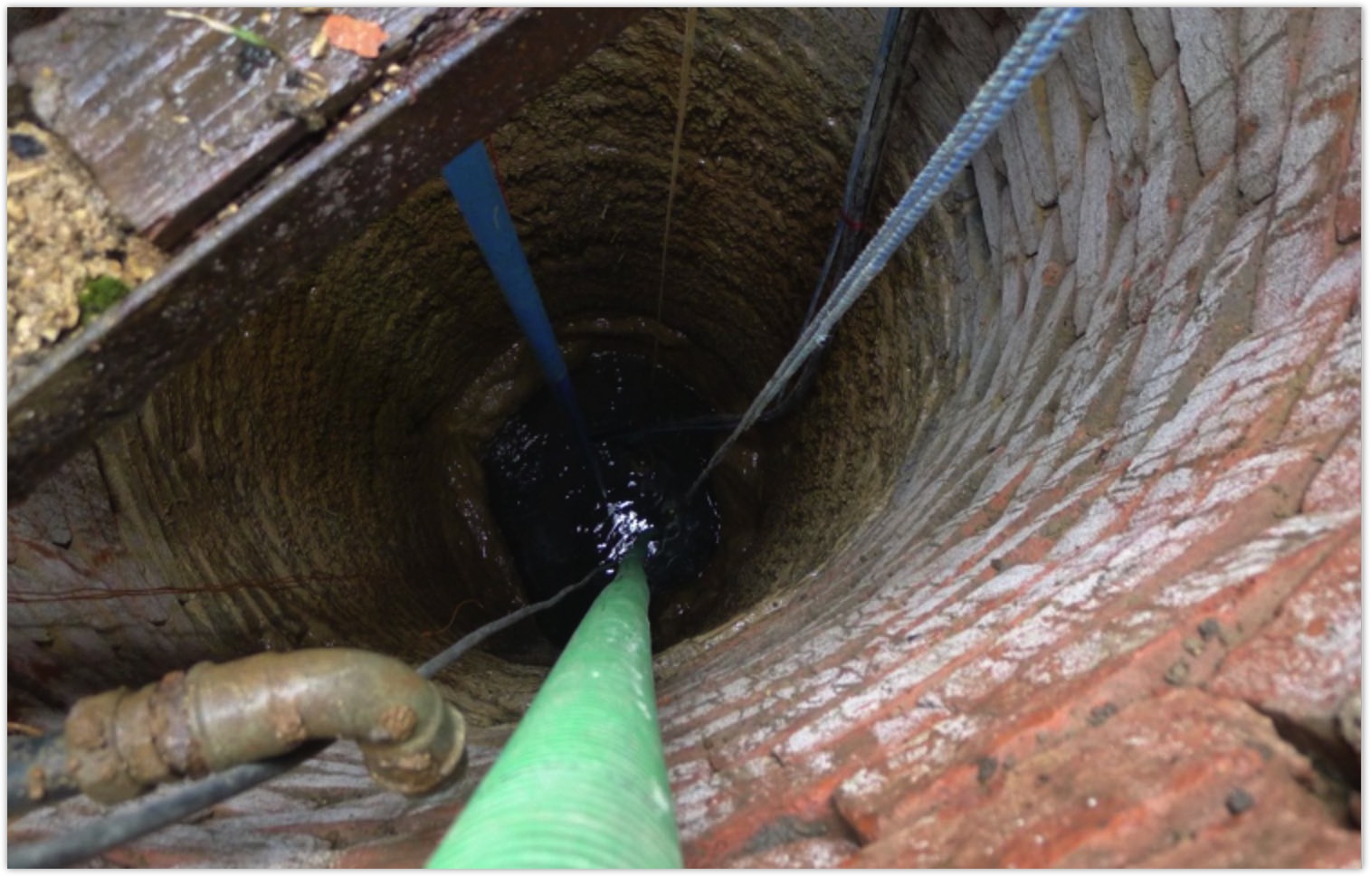
    Cockhaise Groundwater Study, Sussex, UK, 2003
    [South East Water]

    The primary aim was to assess the yield and deployable output of an Ashdown Beds and Tunbridge Wells Sandstone [TWS] groundwater source in the headwaters of the Sussex Ouse, as part of abstraction licence review. At Holywell-Cockhaise, an ancient Chalybeate spring had been exploited for public water supply, using an elliptical large diameter well chamber. The footing of the chamber sits on the Ardingly Sandstone [TWS].
    The Chloride mass balance technique was used to estimate recharge using rainfall at Barcombe Mills characterized by 7.06 mg/l Cl. The mean groundwater Cl from all Holywell data was 19.9 mg/l and it was shown from geochemical plots that this is overwhelmingly derived from marine aerosols. Streamflow averages of 19.9 mg/l Cl from a nearby site suggest that baseflow predominates and that the groundwater Cl signal is derived by evapotranspiration. Mean recharge rate was found to be 269 mm/yr.

    An aquifer test was carried out in 2003, which involved pumping out the well chamber at variable rates, and the drawdown results provided a good basis for assessing performance of the well. The dry year average Deployable Output was calculated using both new and historical records, and the long-term yield of the existing well/spring was estimated to be 1.5 Ml/d.


    Lasham Groundwater Yield Assessment, 2003
    [South East Water]

    Deployable Output assessment of Lasham groundwater source involved re-assessment of the multiple well source at Lasham, near Alton, in Hampshire, using new pumping test data, and advanced step test analysis, using WRA’s software, PtFit, which has been developed for analysing pumping tests at multi-well sites. It can cope with multi-well pumping, complex pumping regimes and automatically determines the well–loss factor which determines well step drawdown behaviour.

    The Lasham source comprises three separate well configurations: one with two interconnected wells, and two distant individual wells, 300m and 560m away from the main site. On the main site, wells are 1800mm in diameter, drilled to a depth of 90 mbgl, and connected by a 91m-long adit at 27.7mbgl. The other two boreholes are 762 and 914mm in diameter drilled to a depth of 91 to 97m.

    Step-Drawdown tests were carried out at all three sites, and software used to analyse the results. Having determined aquifer and well performance characteristics, deployable output was calculated for the required multi-well pumping regime assumed, following UKWIR methodology.

    Well performance was shown to have deteriorated since prior testing in 1988, and the well-loss factor had increased. Acidisation was recommended along with a new pump delivery system. Subsequently, Stow plc was contracted to carry out this work and well retesting showed that performance was restored to pre-1988 levels.
    The calculated DO, assuming wells 1 or 2 provide first delivery, give a yield of 12.5 Ml/d: If well 3 and well 4 are pumped continuously at half the rate of wells 1 and 2, the DO exceeds 30 Ml/d.


    Pembury Springs Investigation, 2004
    [South East Water]

    Pembury springs has been the main water supply for the city of Tunbridge Wells in Kent since the mid-1800’s. The aim of the investigation was to identify ways in which the winter abstraction from the aquifer could be controlled without detriment to the streamflows occurring during the summer.

    The hydrogeology of the principal aquifer, the Lower Tunbridge Wells Sands, was studied, HYSIM modelling to relate daily rainfall to springflows, examination of surface flows, and ecological surveys of the two main streams, Tudeley Brook and Alder Stream. A detailed survey and inspection was also made of all the individual spring locations, tunnel, adits and catchpits and V-notch.

    The chloride mass balance technique was applied to determine the regional recharge rate, and complete the water balance calculations.

    A survey was made of the condition of the tunnel joining springs in the Tudeley catchment with spring-flow in the Adler catchment, noting the presence of leakage, and carrying out flow measurements. As the tunnel is built through the aquifer, the tunnel both gains flow from fractures as well as losing water through the broken clay-pipe aqueduct. Five work components were carried out: groundwater modelling, revisions to the abstraction licence, field monitoring of spring flows, applicability of the chloride mass balance technique, and engineering refurbishment options for the spring system.


    Nutfield Marsh Hydrogeological Appraisal, 2007
    [Nutfield Marsh Residents Group]

    A study was made of sand extraction at Mercers Farm, Nutfield Marsh [east of Redhill] to support a local residents group in questioning the viability of proposals in the Draft Surrey Minerals Plan for the period 2004-2016, and investigate the potential impact on public water supplies.

    WRA’s task was to carry out an appraisal of past and proposed quarrying activities in the Redhill area. The surface-groundwater regime of the Nutfield Mineral Planning Consent area is complex due to the extensive history of mineral workings in the area, in particular, for sand and Fullers Earth.

    The Surrey Minerals Plan [SMP] recognises that the hydrology and restoration of quarried areas are key issues in the selection of sites. At Nutfield, consideration was given to the potential impact on groundwater resources and possible contamination of the site. It was found that Sutton & East Surrey Water’s groundwater source at Brewer Street would most likely be affected by the proposals, although contradictory mapping of EA source protection zones highlighted the need for further evaluation, before the County Council finalised the new Minerals Plan.


    Pinfold Groundwater Development, 2008-2011 [Bedford Estates, Woburn]
    The project included planning studies, preliminary drilling investigation and monitoring, construction of test and production boreholes and delivery system of the new water supply for irrigation of Woburn Golf Club’s three 18-hole championship courses.

    Water level monitoring was carried out to provide baseline data for the aquifer pumping tests. The new production well captures water from the area of the Woburn Sands draining into the Thames Basin, which falls outside the CAMS defined catchment of the Broughton Brook. The work included the process of abstraction licence application and associated surveys.

    The aquifer at this location is semi-confined with downward leakage, resulting in a transmissivity of 35 to 50 m2/d and 0.0035 storage coefficient. The well required extensive development, including high velocity jetting. The aquifer test data were highly influenced by barometric pressure and were corrected using a multiple regression technique prior to analysis by different methods using AquiferWin32.

    GMDL drilled eight small diameter boreholes for installation of piezometers in the Woburn Sands aquifer, in order to investigate the depth of groundwater along the Broughton Brook. This work formed part of the groundwater development programme and Water Strategy project for the Bedford Estates.


    Nitrate Vulnerable Zones [NVZ], 2009
    [Moundsmere Estates, Waterfield and White]

    Hydrogeological assessments were made for farms across the Oxfordshire, Buckinghamshire and Hampshire counties, to provide support for appeal against the extension of the NVZ boundaries. A number of hydrogeological reports were prepared, to assist farmers in southern England to appeal against the revised designation of nitrate vulnerable zones [NVZs].

    The NVZ is an area of surface water or groundwater that has, or is at risk of having, a high nitrate concentration [>50mg/l NO3-N]. In order to combat nationally-increasing trends of nitrate, farmers within a NVZ must reduce their nitrate input to land, by limiting application of livestock manures and by observing closed periods for the application of organic manure.

    NVZs were established by the EC in areas where agricultural nitrates pose a pollution risk, and are designated by the Environment Agency using best available data, but information is not necessarily adequate across all parts of the country. In 1996, 66 NVZs were identified to protect drinking water sources, amounting to 8% of England’s land area, and this was increased in 2002 to cover 55% of England. In 2009, the NVZ area was increased still further, bringing the total cover to 70% of England.

    The appeals were based on evidence to demonstrate that the farmland does not drain into water identified as nitrate-polluted, and/or the water to which the land drains should not have been identified as polluted.
    Following an examination of the topography, soils, geology and groundwater movement to public water supply boreholes, the WRA reports for each farm provided hydrological justification for excluding specific areas from the new NVZs. The reports demonstrated that farm runoff did not drain into a problematic high-nitrate river, and this constituted the main grounds for appeal.


    Barlaston Mineral Water Study, 2010
    [John Sanders Farms Ltd]

    Barlaston is a small village in Staffordshire [England], located on a hill overlooking the valley of the Upper Trent. An area of groundwater springs was assessed to determine the feasibility of developing a bottled groundwater supply, based on capture of the spring water, which flows into the Hartwell stream.

    The underlying geology is Sherwood sandstone at lower elevations, and Keuper marl and Keuper sandstone at higher points in the catchment, with Upper Coal Measures outcropping to the north-east of Barlaston. The sandstones form a significant regional aquifer, and groundwater provides significant baseflow contribution to the local streams.

    The WRA assignment assessed the feasibility of developing a bottled water at the proposed spring, including a broad review of regulatory matters and hydrology:

    • Review of Environment Agency regulatory constraints
    • Hydrogeological and water quality assessment, to assess the yield of the spring, and hence water volume available for abstraction
    • Assess physical conditions at the site, and identify the engineering and costs that would be required to develop a safe and sustainable capture system for the bottling plant.


    Soho Farmhouse groundwater investigation, Cotswolds, UK, 2014
    [Soho Group]

    Soho Farmhouse is an old farm on the Great Tew estate which was the subject of conversion into a modern country club retreat. The Soho studies focused on both deep groundwater for potable supply taken from the Marlstone Rock Bed and shallow groundwater in the Chipping Norton limestone and Clypeus Grit Formations. The work involved water features survey and abstraction licencing considerations, pump testing existing wells, yield analysis and design of potable supply boreholes and monitoring.

    Activities also involved a flooded farmhouse basement area with four rooms requiring dewatering, and an intricate network of old wells, catchpits and drains. Fluorescein was carefully injected at key points in the drainage system to trace interpreted links between various catchpits and manholes, and the river system. GMDL provided the on-site pumping and testing equipment.


    Briary Lodge Private Water Supply, Midlands, UK, 2016
    [Jackson-Stops Estate Agents]

    Briary Lodge was a disused farm at Lillingstone Lovell in Northamptonshire, in a shallow valley at the head of Deanshanger Brook, a tributary of the Great Ouse.

    The primary objectives of the project were to assess the feasibility of obtaining groundwater in sufficient quantity and quality for potable supply, and prepare the preliminary design for costing of a private water supply scheme of up to 20 m3/day.

    The work involved Acquisition of data, Reconnaissance and measurement, Hydrogeological analysis and yield assessment, Procurement of drilling contractors and evaluation of quotations, Preliminary design of boreholes and water supply system.

    The farm lies in close proximity to the junction between the Blisworth Clay and Blisworth Limestone Formations and the target water supply aquifers are the Blisworth and Estuarine Series limestones.

WRA Services Summary and Skill-set

  • Groundwater investigations [desk, reconnaissance, survey]
  • Groundwater exploration and development
  • Groundwater modelling [MODFLOW, GFLOW, MT3D, MOC3D, SEAWAT]
  • GIS applications for groundwater mapping
  • Pumping tests [Win32, PtFIT advanced step test analysis]
  • Regional and local groundwater modelling
  • Diverse forms of engineering design: boreholes, dug-wells, horizontal aquifer drains, collector wells, adits and well-points
  • Groundwater monitoring, hydrometrics and geophysical survey
  • Groundwater control/dewatering design and optimisation
  • Managed aquifer recharge and recharge dams
WRA provides a complete service from initial strategy and concept through design and construction supervision to commissioning. This gives WRA’s hydrologists a unique insight into the full spectrum of activities and problems which can affect groundwater development and conservation projects.
© 2024 Water Resource Associates LLP | Website by Boray Designs

Privacy Policy Cookie Policy